A4095 / B4100 Banbury Road roundabout improvements
We are converting the existing roundabout into a signalised junction with traffic lights to improve traffic flow and encourage more walking and cycling.
Information event – 11 July
The next information event will be held at the Emmanuel Church, 2 Barberry Place, Bicester, OX26 3HA on Thursday 11 July, from 3pm to 7pm. You can find out more about our plans for phase three and the remainder of the programme and ask the project team questions. Car parking is available.
About the project
Confirmed design for construction
Bicester is one of the fastest-growing towns in Oxfordshire and the Banbury Road roundabout is a key junction along the Bicester ring road which was identified as a site for improvement in our Local Transport Plan.
The junction must be able to safely handle the number of vehicles travelling in the area, when new homes and jobs come to the town, and provide improved facilities that encourage more people to walk and cycle.
We are redeveloping this junction, and the work will:
- convert the existing roundabout into a signalised junction better able to cope with increased traffic levels
- improve safety for cyclists and pedestrians, with segregated cycleways and crossings at the western and southern arms of the redesigned junction
- increase capacity, helping to address congestion
- maintain access for drivers making a right turn from Fringford Road
- incorporate a reduced speed limit of 30mph.
What you can expect
We are working in phases to remove the existing roundabout island and construct the improved junction.
The timeline and detail of this work may change, due to the complexity of the project, any unexpected discoveries in the ground and weather conditions.
Phase one is now complete
Phase two timeline
| Dates | Location | Activity | Day/night | Traffic management | Pedestrian and cyclists |
|---|---|---|---|---|---|
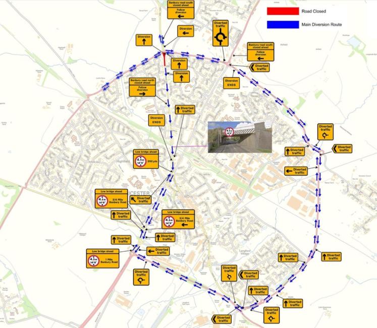
| 9 May to June 14 | Existing roundabout | Remove existing roundabout and islands | 24 ours, 7 days a week | Fringford Road remains closed. A route will be available around the roundabout via narrow lanes and four-way manned temporary traffic lights. |
Fringford Road footway and pavement closed until end of May. Diversion as above. Bridleway closed when Fringford Road footway and pavement opens at end of May. Temporary pedestrian crossings in place. |
| 8 May to 29 July | B4100 Banbury Road northbound | Works associated with widening of the southbound approach of the B4100 | 24 hours, 7 days a week | Fringford Road remains closed. A route will be available around the roundabout via narrow lanes and four-way manned temporary traffic lights.. |
Fringford Road footway and pavement closed until end of May. Diversion as above. Bridleway closed when Fringford Road footway and pavement opens at end of May. Temporary pedestrian crossings in place. |
Phase three timeline
Phase two traffic management will remain in place until 22 July
| Dates | Location | Activity | Day/night | Traffic management | Pedestrian and cyclists |
|---|---|---|---|---|---|
| 1 July to 22 July | A4095 westbound | Work in the southern verge to divert communications and electricity cables | 24 hours, 7 days a week | No traffic management or diversion required. | No change to access |
| 22 July to 28 October | Banbury Road | Closing the southern side of Banbury Road, from the roundabout to Lodge Close | 24 hours, 7 days a week | Narrow lanes used on the northern half of the road to manage traffic. Traffic towards Bicester diverted both ways via the ring road. Fringford road reopened. | Bridleway re-opened. |
More information on phase three of work
During the Banbury Road closure our teams will be:
- working to create a new island on Banbury Road south
- installing a new central island adjacent to the Fringford Road and on the roundabout east and west approaches
- completing the second half of the toucan crossing on the A4095
- constructing new drainage and footways
- and surfacing the Banbury Road south up to the roundabout approach splitter island.
The timeline and detail of this work may change, due to any unforeseen discoveries in the ground, adverse weather conditions, or other complexities. We expect phase three to finish by the end of October, after which the Banbury Road will reopen to all road users.
Phase four timeline
| Dates | Location | Activity | Day/night | Traffic management | Pedestrian and cyclists |
|---|---|---|---|---|---|
| 29 October to 31 January 2025 | A4095 westbound | Works associated with widening of the northbound approach of the B4100 | 24 hours, 7 days a week | Banbury Road re-opened to traffic. Narrow lanes in place. | Details to follow |
Phase five timeline
| Dates | Location | Activity | Day/night | Traffic management | Pedestrian and cyclists |
|---|---|---|---|---|---|
| 3 February 2025 to 7 February 2025 | B4100 | Road closure, road surfacing | Night time | Diversion via B4100 up to B430 and onto the ring road | Details to follow |
| 3 February 2025 to 18 February 2025 | Various locations | Finishing and electrical works completed as required | Day time | Localised traffic management | Details to follow |

Diversion route in place for drivers until late July 2024; no change from phase one of construction.
Temporary traffic diversion route in place during phase three, from July to October 2024. Traffic towards Bicester will be diverted both ways using the ring road.
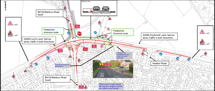
Traffic management plan with pedestrian and cyclist diversion route indicated in green. Pedestrians will be diverted along the Banbury Road. The existing footpath will be maintained at a reduced width and with a barrier installed. Cyclists will be directed to follow the pedestrian diversion, with the cycle path width reduced in places to facilitate shared used with pedestrians. The bridleway will be reopened.
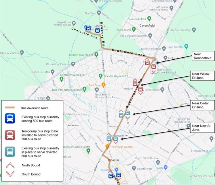
Bus diversion route (500 - Banbury – Bicester) with temporary bus-stops indicated in red. Buses will be diverted using the Buckingham Road, with two new temporary bus stops in each direction provided for the 500 bus route.
How can I stay up to date?
This web page will be updated regularly.
We recommend signing up to our travel and transport bulletin
Satellite navigation systems (SAT-NAV) will display updates on the road closures which could help when planning journeys.
Traffic management arrangements are also available by visiting https://one.network/
Feedback
| You asked us to... | We... |
|---|---|
| Act on reports of traffic violations within the work area and take action on vegetation that needed clearing and potholes that needed fixing. | Have logged these issues in Fix My Street. |
| Allow for safer crossing for pedestrians, especially children. | Adjusted the phase timing of the traffic lights and put up caution children crossing and look both ways signs |
Contact us
If you would like to get in touch, please email banburyroadroundabout@oxfordshire.gov.uk. or write to Oxfordshire County Council, County Hall, New Road, Oxford, OX1 1ND. You can also register your interest in receiving updates about the work.
How it is being funded
The scheme budget for the improvements is £10.7m. The Department for Levelling Up, Housing and Communities are providing £5.5m, with £5.20m secured from the Growth Deal. The money can only be used for this scheme.
More information
Why are these improvements needed?
With more than 6,000 new homes planned for the local area, data forecasting shows that the current roundabout will not be able to safely handle the volume of predicted vehicle traffic. The redesigned junction will improve safety for drivers, cyclists, and pedestrians by regulating traffic in a more structured way using signals and lower speed limits.
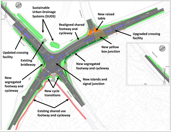
What will the new junction look like?
The existing roundabout will be converted into a signalised junction. We are adding segregated crossings and paths for pedestrians and cyclists at the western and southern arms and reducing the speed limit to 30 miles per hour.
Why does the speed limit need to reduce?
Due to the crossing and raised table included in the new design, it is a legal requirement to reduce the speed limit to 30 miles per hour.
Why are you trying to encourage more walking and cycling?
Encouraging more people to walk, cycle or take public transport if they can is a key ambition of our local transport and connectivity plan. The redesigned junction will have better pavements and cycle paths and safer crossings, to help us achieve this.
How did you decide on the design?
An online public consultation on the initial three design options was held from 19 March to 9 April 2021. You can read the findings of the consultation in full (pdf format, 3.5Mb).
A member-delegated decision was made to take option two and develop it into a signalised junction with additional provision for safe cycling.
Further changes were incorporated following a review of the scheme in 2022 and additional stakeholder engagement in 2023. The change of design was approved at a cabinet member delegated decision meeting in October 2023.
As we have worked on the design, we have used consultation and planning application feedback, technical assessments and data modelling, safety reports, and a cost review to inform our thinking. We also considered council policies.
Why was the design changed?
Emerging cost pressures led to a review of the scheme in 2022. The scope of the work changed, and we revisited the design to reflect this. The current design should save money and have a reduced impact on the surrounding land, while maintaining features such as segregated cycleways and crossings.
How is the current design different from the old design?
The current design increases the vehicular capacity of the junction to a similar level as options one and two from the original consultation, includes segregated cycleways and crossings that are an improvement on the existing provision, and has a reduced impact on the surrounding land, as we do not plan to widen the highway as much as originally planned. This avoids the potential requirement for compulsory purchase orders and expensive delays which could lead to funding expiring.
The design is compliant with guidance and two road safety audits have taken place.
What safety improvements will be made for cyclists?
Buffer zones between the cycle track and the carriageway have been incorporated on the north-western section which is a key area of vulnerability where traffic turns and where we expect most cyclists to travel.
The speed limit will also be reduced from 40mph to 30mph on all arms of the junction.
When was planning permission granted?
Planning permission was granted in November 2021 for a signalised junction to replace the existing roundabout. We submitted a follow-up Section 73 application in 2023 to take account of minor changes required.
What engagement have you done?
We have used consultation feedback, planning application feedback and conversations with community representatives to help us make decisions as we developed these improvements.
In 2021 we held a public consultation on three options for the redesigned roundabout. Further engagement took place with members and a community cycling group, including a June 2021 meeting with councillors.
Throughout 2023, we met with local interest groups as we finalised the current design.
An engagement event to provide information on the scheme was held for residents on 4 October 2023 to:
- provide residents with an update on the progress of the scheme’s design
- to explain the rationale behind the decisions made along with results from the modelling that supported the decision to deliver a signalised junction over a roundabout
- to explain how the construction phase will be delivered and how traffic will be managed during the works
- and answer any queries they may have on the design and construction process
We held a second event on 28 February 2024 to provide information on:
- the construction phases
- traffic management used
- and how we have responded to feedback and mitigated issues on site
We have also engaged with various disability and access groups, local horse-riding societies and some local businesses.
How will you mitigate the environmental impact in the area?
The construction will be delivered in line with a Section 61 agreement – a formal agreement about how the work and its impact will be managed – reached between Cherwell District Council, Oxfordshire County Council and our contractor.
Vibrations: We don’t expect vibration to have an impact. This was assessed through ground investigation works.
Traffic congestion: A traffic and pedestrian management plan was produced and reviewed as part of the planning process. Our contractor assessed and mitigated the risks associated with the movement of vehicles, large machinery, and pedestrians (both site workers and members of the public) around the site.
Light pollution: We plan to install enough temporary lights to ensure the safety of road users is not compromised. We will maintain existing lighting levels around the junction and will not increase the light levels at night. Any flood lights installed in the compound will be angled down to limit light pollution.
How will you mitigate noise and air pollution in the area?
We will ensure that all tools are fitted with silencers and additional machinery and equipment are positioned furthest away from areas where the public could be affected and behind noise barriers. Noise will be reduced through planning, using quieter equipment, using anti-vibration mounts, training, and communication of and with the workforce. In addition to this, a noise monitoring system will be used to evaluate how our activities affect the surroundings.
To mitigate dust and air pollution, we will choose pre-made construction materials to reduce on-site activities. We will also use dust suppression equipment during the works.
Will there be enough space for cyclists, people with pushchairs, and people using wheelchairs or mobility aids to pass through during construction?
Yes, two metres of space will be provided and protected by barriers during construction.
Why did our plans for phase two of construction change?
We listened to feedback about phase one of construction and reassessed our plans for phase two. The assessment showed us that changing the traffic management by opening Fringford Road and adding a fifth traffic signal to the traffic management arrangement would cause more disruption. This is because an onsite officer would find it difficult to oversee five-way signals efficiently.
As a result, Fringford Road remained closed to drivers until the end of July 2024 and the existing four-way traffic signal arrangement overseen by an onsite officer remained in place.